HVH Pick
Hiking • Scenic
Giant Ledge

What They Are about
Hike Description:
This hike climbs Giant Ledge, one of the most popular destinations in the Catskills, which features spectacular views from a series of ledges. The hike continues to Panther Mountain, one of the 35 high peaks in the Catskills over 3,500feet in elevation. Although Panther also offers panoramic views from its summit, they are quite similar to those from Giant Ledge. If you’re interested only in the views, you might want to turn back after climbing Giant Ledge. Many of those who continue ahead to Panther are “peakbaggers,” whose goal is to climb all of the Catskill high peaks. Either way, this is not a loop hike, and you’ll have to return the way you came. The elevation gain from the trailhead to the top of Giant Ledge is about 1,000 feet, and if you continue to Panther, you will have climbed nearly 2,000 feet (including the climb back up Giant Ledge on the return trip).
The trailhead is at the hairpin turn in the road, just above the parking area. For the first part of the hike, you’ll be following the yellow blazes of the Phoenicia-East Branch Trail. After crossing a short bridge, you’ll come to the register box (please sign), with a kiosk across the trail. A short distance beyond, you’ll cross a longer wooden bridge over the Esopus Creek. The trail now begins to climb on a rocky woods road, steeply in places.
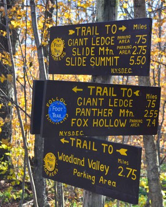
In about three-quarters of a mile, after climbing a vertical distance of about 500 feet, you’ll come to a junction, marked by a sign. Turn left at the junction, now following the blue blazes of the Giant Ledge-Panther-Fox Hollow Trail. You’ll be following this trail all the way up Giant Ledge (and, for those continuing to Panther, all the way there, too).
At first, the trail follows a relatively level woods road, with a few minor climbs. This section of the trail is often wet, and large rocks have been placed in the middle of the trail to help keep your feet dry. After about half a mile, the trail begins a steady climb, soon passing a side trail on the left that leads to a spring.
After climbing about another 350 feet in elevation, you’ll reach the top of Giant Ledge. The trail goes by a series of east-facing ledges, which offer spectacular views. To the east (straight ahead), you can see the ridge of Romer Mountain, Mt. Pleasant and Cross Mountain, traversed by the Long Path (officially designated as part of the Phoenicia-East Branch Trail). Behind this mountain range, the peaks of the Devil’s Path are visible. To the right (southeast) are Wittenberg, Cornell and Slide Mountains (the view of Slide is partially obscured by foliage). You’ll want to take a break on one of these ledges to rest from your climb and enjoy the views.
Giant Ledge is a very popular destination, and you will likely find other hikers along the ledges. If you continue beyond the first ledge, though, you might be able to find a ledge to yourself.
If you decide to end your hike at Giant Ledge, just retrace your steps to return to the trailhead (be sure to turn right onto the yellow-blazed Phoenicia-East Branch Trail when you reach the junction). But if you want to continue to Panther, proceed ahead on the blue trail, which descends about 200 vertical feet to a col, where it levels off for a short distance. It then begins a steady ascent of Panther, rather steeply in places.
After climbing about 200 vertical feet, look for an unmarked side trail on the right, which leads to a rock ledge with a view to the southeast. This ledge offers an unobstructed view over Slide Mountain, the highest peak in the Catskills.
After taking in the view, return to the trail, turn right, and continue your climb of Panther. You’ll soon come a flat area, with an unreliable spring. Just beyond, the trail climbs rather steeply over rock ledges. It continues to climb a little less steeply, and enters a balsam fir forest – characteristic of the high elevations in the Catskills – about 3,400 feet in elevation.
Beyond this point, the grade moderates. When you reach a large rock outcrop to the right of the trail, with an expansive east-facing view, you’ll know that you’ve reached the summit of Panther Mountain (elevation 3,724 feet). You’ll want to stop here to rest from the climb and admire the view. Although this is the highest point on the mountain, there are several other viewpoints in the next quarter mile along the summit ridge, and you might want to continue north for a short distance to take in these additional viewpoints.
Retrace your steps to return to the trailhead, making sure to turn right when you reach the junction with the yellow-blazed Phoenicia-East Branch Trail.


